California’s wildfire threat continues to grow, with longer and more intense fire seasons becoming the new normal. This makes it important for homeowners to understand where wildfire risk is highest in the “Golden State.” New state wildfire hazard maps are shaping the outlook for 2026. These designations, known as Fire Hazard Severity Zones, are essential for planning and wildfire preparedness.
In this blog, we will outline the highest-risk wildfire danger zones projected for 2026 and the factors behind these classifications. We will also discuss how these zones may affect you and how you can prepare to face new wildfire challenges in 2026. This preparation includes installing fire-resistant vents, using Class-A roofing material, and more. Let’s discuss this in detail.
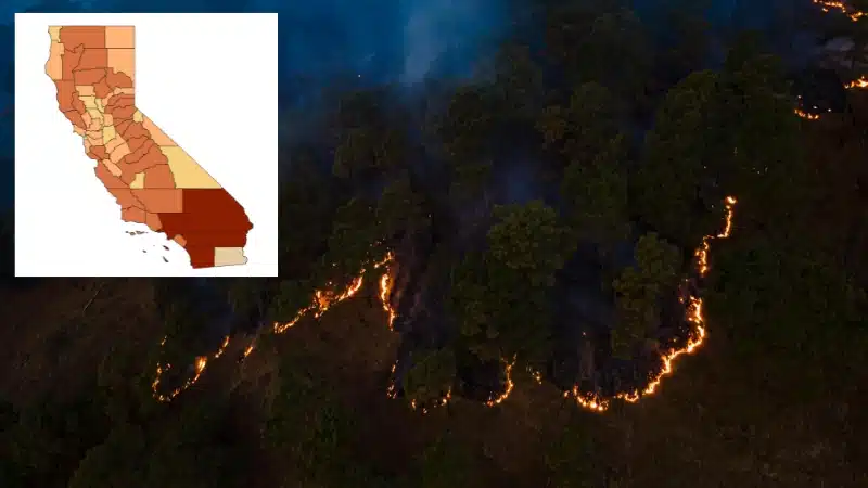
What Are California’s Fire Hazard Severity Zones?
To determine where wildfires are most dangerous in California, officials use a specialized map. This map, called the Fire Hazard Severity Zone map, sorts areas into three risk levels- Moderate, High, and Very High. These science-based classifications consider burnable vegetation, terrain slope, historical fire activity, and local weather patterns. All these elements influence wildfire danger.
Why the 2026 Wildfire Zone Map in California Matters
Fire Hazard Severity Zone maps of California are updated in early 2025. The updated maps reflect a bitter truth- wildfire risk is expanding into more populated regions. The update continues toward 2026 and is the first major update in over ten years. The changes are significant. Over 2.3 million acres were added to high-risk designations.
Analyses indicate roughly one in eight Californians now lives in a High or Very High wildfire danger zone under the new models. This expansion is driven by improved scientific understanding of ember transport, the ability of fires to jump large distances, and the inclusion of recent wildfire event data.
Highest-Risk Wildfire Danger Zones in California for 2026
The wildfire zone in California is the greatest concern for 2026. Updated hazard maps and fire trends identify them. The most concerning regions include:
The Sierra Nevada Foothills and Eastern Sacramento Region
This zone, stretching from the area east of Sacramento through communities such as Placerville and Grass Valley, is consistently classified as Very High. The combination of dense, often drought-stressed forest fuels, topography, and wind patterns creates conditions in which fires can ignite easily and spread rapidly. The wildfire zone map consistently shows a deep red swath across this region, underscoring its continuous vulnerability.
Northern California’s Forested Valleys and River Canyons
Areas north of the Bay Area, including the terrain around Oroville, Chico, and the Sacramento River Canyon, face increased risk of wildfires. These regions have been repeatedly scarred by major fires in recent years, which reset fuel cycles. However, it leaves behind landscapes vulnerable to rapid reburn. Dry lightning events and long-term drought have further stressed vegetation, making these forested valleys among the highest-risk wildfire danger zones.
The Wildland-Urban Interface Surrounding the Bay Area
The updated models extend the High and Very High hazard zones deeper into the Bay Area’s urban fringe. Neighborhoods built into scenic, wooded hillsides and ridges, where development directly meets heavy vegetation, now see formalized increased risk. The updated wildfire zone map in California increasingly highlights these interface areas. This indicates the threat is not just in remote wilderness but also where homes meet flammable landscapes.
Southern California’s Mountain and Coastal Ranges
The areas adjacent to the Santa Monica and San Gabriel Mountains, along with the interior valleys, remain at very high risk. The primary accelerant here is the Santa Ana wind, which can transform a small ignition into a fast-moving firestorm that spreads into densely populated basins. The historical frequency of major fires in these corridors solidifies their standing as some of the state’s most volatile wildfire danger zones.
Note: To know more, click on how Santa Ana winds contribute to California wildfires.
How the Fire Hazard Zones Will Affect Residents in 2026
The wildfire zone map in California has real impacts. Homeowners in High or Very High zones must follow strict codes. They need fire-resistant vents and roofing. Defensible space clearance is often mandatory. Maintaining defensible space, often a minimum of 100 feet of cleared vegetation, transitions from advice to a legal requirement.
Furthermore, living in a high wildfire danger zone can affect premiums. Insurance coverage may become more expensive or difficult to secure. For local governments, adopting the updated wildfire zone map into ordinances is an important step. It guides land-use decisions, zoning, and the allocation of emergency resources, ensuring community planning aligns with the current best understanding of wildfire behavior.
Wildfire Preparedness Steps for Your Home in California in 2026
If you live in a wildfire zone in California, preparation is essential. This includes:
- Know Your Zone: You should check the official Cal Fire Fire Hazard Severity Zone maps online to find your property’s specific wildfire risk designation (Moderate, High, and Very High). This is the essential first step for all preparedness efforts.
- Create Defensible Space: Clear all flammable brush, grass, and vegetation within 100 feet of your home. Establish a non-combustible zone of at least five feet immediately around your house’s structure using gravel or hardscape.
- Harden Your Home: Install fire-resistant building materials like Class-A roofing and ember-resistant vents with metal mesh. Upgrade to tempered-glass windows and box-in eaves to prevent ember intrusion during wildfires.
- Prepare an Evacuation Plan: Identify and practice using multiple exit routes from your neighborhood. Pack a “go bag” of emergency supplies and important documents. Always sign up for your county’s local emergency alert system to receive timely warnings.
Note: To know more, click on “Is Your Home Prepared to Withstand a Wildfire Ember Storm?”
Conclusion
California’s wildfire risk is growing, with more people living in high-hazard areas in 2026. If your home is in a High or Very High zone, you must comply with stricter building codes and maintain a clear defensible space. Checking the official map is the necessary first step. Once you know your risk level, take action to protect your property and prepare your family to evacuate. You should also harden your home by installing Class-A roofing and ember-resistant vents.
At Vulcan Vents, we view these maps as a guide for protection. For over a decade, our goal has been to help homes in high-risk areas become more secure. Our ember-resistant vents meet strict Chapter 7A building codes. They are tested in accordance with ASTM E2886. This makes them a significant part of your home’s defense during a wildfire. Choosing our vents for the wildfire zone in California helps you prepare your home for 2026 and beyond. Contact us today!

